
If you are looking for BGYET-141 IGNOU Solved Assignment solution for the subject Ore Geology and Industrial Minerals, you have come to the right place. BGYET-141 solution on this page applies to 2021-22 session students studying in BSCG courses of IGNOU.
BGYET-141 Solved Assignment Solution by Gyaniversity
Assignment Code: BGYET-141/TMA/2021-22
Course Code: BGYET-141
Assignment Name: Ore Geology and Industrial Minerals
Year: 2021-2022
Verification Status: Verified by Professor
Marks: 100
PART A
Q1) Write short notes on the following:
a) Explain the syngenetic deposits associated with different types of rocks.
b) List the characteristic features of a typical Volcanogenic Massive Sulphide (VMS) deposit.
Ans)
a) Igneous, sedimentary, and metamorphic rocks all contain ore. As a result, their connection represents the genetic process of ore production. The words syngenetic and epigenetic refer to the genesis of ore bodies and indicate whether the ore body was created concurrently with the host rock (i.e. syngenetic) or after the host rock was formed (i.e. epigenetic) (i.e., epigenetic). Because they form at the same time as the host rocks, magmatic (igneous) and sedimentary deposits are frequently syngenetic. As a result, they're known as syngenetic deposits. Ore bodies that originate at the same time as their host rocks are known as syngenetic ore bodies. Whether the host rocks are sedimentary or igneous, they invariably contain the mineral deposits. The host rock and the ore body share a genetic relationship.
Syngenetic deposits can be classified into two groups. They are as follows:
Syngenetic Deposits Associated with Igneous Rocks: Magmatic ore deposits are syngenetic in the sense that ore minerals crystallise at the same time as the host rock-forming minerals, i.e. igneous rock-forming minerals, in the magma. Magmatic separated ore deposits, for example, are generated during the crystallisation of magma contained within igneous rocks. They're usually uneven and roughly spherical in shape, with tabular or lenticular shapes being more common. Magmatic nickel-copper iron-PGE deposits, magmatic Ni-Cu-Fe-PGE deposits, vanadiferous or platinum-bearing magnetite deposits, chromite deposits, and Komatiite hosted Ni-Cu-PGE deposits are just a few of the magmatic syngenetic deposits.
Syngenetic Deposits Affiliated with Sedimentary Rocks: Sedimentary related syngenetic type deposits are ore deposits that originate on the Earth's surface in layered form and are housed in sedimentary rocks. Metallic ores, coal beds, rock salt, gypsum, and anhydrite beds, which can be hundreds of feet thick, are all examples of sedimentary syngenetic ore deposits. Because they form at the same time as the host rocks that surround them. Peninsular India's Gondwana coal deposits are a good example of syngenetic deposits. The alluvial and colluvial placer diamond deposits on the Baghain plateau of the Vindhyan Supergroup are a notable example of syngenetic sedimentary ore deposits.
b) The characteristic features of a typical VMS deposit are:
i) It is found in conjunction with mafic and/or felsic volcanic rocks and is usually restricted to volcanism's disturbances.
ii) It occurs as strata bound to stratiform sulphide deposits containing iron, copper, and zinc, as well as lead mineralization.
iii) Bulbous lens deposits with massive ore produce acute contact with hanging wall rocks and gradational contact with footwall rocks. Under the bulk ore, a discordant body with dispersed and stockwork mineralisation is concentrated stratigraphically.
iv) Minerals ranging from chalcopyrite to sphalerite and galena are zoned uphill and laterally. Sulphides of iron are also abundant in all zones.
v) The changed zones of the footwall rocks frequently show chloritization and sericitization.
vi) The presence of iron in sanguiferous siliceous sediments is due to chemical precipitates on the seafloor during hydrothermal activity's final stages.
Q2) What is reserve estimation? Discuss the main methods of ore estimation with suitable diagram.
Ans) Reserve estimation is a critical task in the mining industry in which the economic feasibility of one or more minerals, elements, or mineral assemblages from an ore deposit is quantified. Ore reserve estimation is an important step in the planning and development of ore deposits. Ore-reserve estimates are a technique that involves estimating the average grade and tonnage of ore resources. It is impossible to estimate mineral reserves precisely due to geological complexity and mining concerns.
The field effort in sample measurement, collecting, preparation, and assaying is the most important task in estimating mineral reserves. Various strategies are used to better comprehend and know the mineral reserve estimation connected to sampling. The primary goal of ore reserve estimation is to verify the quality and quantity of ore, as well as to estimate the costs of extraction and other relevant tasks involved in preparing the ore deposit for mining. The assessment of reserves is influenced by a variety of factors.
Methods of Ore Estimation
The main methods of ore estimation are:
Geometric Methods: These are some of the oldest approaches that are still widely used and recognised today. Geometric approaches are solely based on the ore body's shape. These methods have the advantage of being unbiased when estimating tonnage. However, the problem of these methods is that they rely on point estimates, which make it impossible to assess quality objectively. Different approaches are used to estimate geometric methods, such as:
Triangle Method: It's a straightforward method for estimating reserves that relies on traditional triangle calculations.
Polygon Method: This method of estimating reserves has some advantages over the triangle method. However, in practise, the traditional triangle and polygon approaches produce equal results.
Rectangular Method: It's also known as the block method, and it's a subset of the polygon technique's representation. In reserve estimate, this method is rarely employed.
Cross-Section Method: This method can be thought of as a subset of the polygon method. It is particularly useful in reserve estimating situations where data is found laterally across geological cross-section sequences.
Contour Method: This method is grouped between the cross-section and mathematical methods in a hybrid pattern.
Geostatistical Methods: Geostatistical approaches are extensively used in mining operations, particularly in reserve estimation, to handle numerical data. They are thought to be a more precise procedure. It is useful in enumerating geological properties for reserve estimate on both a theoretical and practical basis.

Q3) Discuss in detail the Lindgren’s Classification of ore deposits
Ans) Many classifications were proposed during the twentieth century based on the types of rocks that contain ore deposits, the geometry of the deposit, and its relationship to its host rocks. However, Waldemar Lindgren, a well-known American economic geologist, established a popular classification. He identified ore deposits that formed at different levels in the crust, coining the names epizone, mesozone, and catazone to describe deposits that formed at shallow, middle, and deep depths inside the crust, respectively, and his notions are still in use today.
Lindgren's Classification, first published in 1911, is a genesis-based classification of mineral deposits. The deposits are primarily created by two processes, mechanical or physical and chemical, according to his classification. The following table shows the detailed classification:

In 1933, Graton proposed two modifications to Lindgren's classification. He altered the ore formation process by introducing two assemblages: leptothermal (above mesothermal) and telethermal (above epithermal, i.e., created at shallow depths and low temperature). Buddington introduced a new type of hydrothermal deposit known as a 'xenothermal' deposit in 1935, which forms at high temperatures and shallow depths. Lindgren expanded his classification in 1922, integrating more ore deposits such as emanation deposits (sublimates, exudation veins, and pyrometasomatic) and magmatic deposits (orthotectic and pneumotectic).
Q4) Discuss the different processes of formation of early magmatic deposits.
Ans) Early magmatic deposits, also known as orthomagmatic deposits, are known to arise directly from magmatic processes at an early stage of magma crystallisation. Different ore forming processes characterise these deposits, most notably:
simple crystallisation without the process of concentration;
segregation from the early crystallised minerals; and
injection of the mineral crystals concentrated and differentiated at a different
place.
Dissemination: It is the production of granular igneous rock or the host rock as a result of simple crystallisation of deep-seated magma.
The early, or largely produced crystals, are dispersed throughout the host rock. The production of scattered magmatic deposits occurs when the disseminated crystals are valued and numerous. South Africa's diamond-bearing kimberlite pipes, as well as the diamond-bearing kimberlite pipes of Majhagawan, Madhya Pradesh, and Wajrakarur, Andhra Pradesh, are good examples of dispersed ore deposits.
Magmatic Segregation: Certain ore minerals localised in different parts of the magmatic chamber crystallise in the early stages of magmatic cooling. Gravity settling causes some of the heavier early produced minerals to settle down in the bottom part of the magma chamber. The creation of early magmatic deposits occurs when these minerals aggregate in greater quantities in the form of layers and have economic worth. Magmatic cumulates are the minerals that arise as a result of the magmatic segregation process. The chromite deposit is the best example. Chromite is a high-specific gravity, high-temperature mineral. When ultramafic lava crystallises, it descends to the bottom of a magma chamber and forms strata of huge ore, as well as layered intrusions of ultramafic and mafic rocks.
The minerals deposited during the early stages of magmatic segregation are often lens-shaped, unconnected, and smaller in size. The stratiform and banded chromite deposits of Odisha's Sukinda-Nausahi ultramafic belt, for example. These deposits are uncommonly seen in host rock strata. Layered type deposits are particularly common in South Africa's Bushveld igneous complex, where significant volumes of magma intruded into sedimentary rocks, resulting in a saucer-shaped ore body.
Magmatic Injection: Some of the early produced crystals are separated and injected into the host rock or neighbouring rocks during the gradual crystallisation of magma. Injection deposits are formed as a result of this. Crystallisation and segregation occur in the magmatic chamber in the same way that separated deposits do. The difference between these two types of deposits is that injection deposits travel away from their original accumulation site.
By examining the structural properties of the enclosing rocks, the injection process can be demonstrated. They are found as dykes and other intrusive bodies, such as concordant and discordant, that intrude into rock structures. There is a chance that the encased rocks will metamorphize in some cases. Kiruna, Sweden's magnetite resources are a good example. A noteworthy Indian example is the vanadiferous magnetite deposits that occur as veins and lenses inside the ultrabasic rocks of Dublabera in the Singhbhum region of Jharkhand.
Q5) Describe the classification of hydrothermal fluids with a neat diagram.
Ans) In the Earth's crust, various forms of hydrothermal fluids evolve. Though the origins of hydrothermal fluids are similar, the content and temperature of creation differ. As a result of the shift in these conditions, hydrothermal fluids act differently in the creation of various mineral deposits. Hydrothermal fluids, which are mostly rich in saline solutions, are active and extensive throughout the Earth's crust. Water is the most important component in these fluids, and it comes from a variety of places. As a result, hydrothermal fluids are named after different types of water and classed according to the formation's depth and temperature. They are as follows:
Sea Water
This type of water is widely distributed throughout the ocean's crust. The movement of metallic ions in the marine crust is facilitated by sea water. This water seeps through the major faults and into the ground. It is found in the ocean's mid-oceanic ridges and is thought to be the source of different deposits, including volcano massive sulphide (VMS) deposits.
Meteoric Water
Meteoric water is the term used to describe both surface and ground water. The meteoric water dips deep into the crust, where it reaches a zone of high heat flow, absorbs heat and dissolved elements from the surrounding rocks, and forms hydrothermal ore deposits. Low temperature and precipitation are common characteristics of the deposits formed, such as sandstone hosted deposits.

Connate Water
Connate water is water trapped within the pore spaces of sedimentary rocks. This water reacts with the host rocks, resulting in a mineral composition that is enhanced. Several hydrothermal ore deposits have been formed using the enhanced fluid.
Metamorphic Water
Metamorphic water is the water produced by dehydration processes during the metamorphism process. High temperatures (> 300°C) are required for the formation of these waters. Metamorphic water is produced in the lower crust as a result of the dehydration and decarbonation caused by prograde metamorphism. Experiments on rock samples from the Witwatersrand Basin in South Africa, for example, show that metamorphic water was produced during metamorphic reactions when subjected to high temperatures.
Magmatic Water
Magmatic water is created as magma cools. It is the most rudimentary or juvenile water of all the waters. Magmatic water circulates at various depths in the Earth's crust and is enriched with a variety of dissolved components, including a considerable amount of metal. At various stages of magmatic crystallisation, this mineral-rich circulating water cools and crystallises, resulting in metal concentration. A variety of important types of ore deposits are based on these metals. The tungsten deposit in the Degana area of Rajasthan, North West India, is an excellent example of an ore deposit generated by magmatic hydrothermal solutions.
PART B
Q6) Discuss the mode of occurrence of iron ores.
Ans) In diverse geological units, iron can be found in igneous, metamorphic, and sedimentary rocks. Based on their origin and mineralization, Indian iron ore deposits can be categorised into five basic categories. The distribution of iron ores in India.
Precambrian Iron Ore Deposits: The Iron-ore Series of Jharkhand and Odisha, Bailadila Series of Chhattisgarh, and Dharwar Supergroup of Goa and Mysore all have large hematite resources. The high-grade iron ores are found at the top, with the grade decreasing as the ore gets closer to the bed rock. Jharkhand, Odisha, and Karnataka have lens-shaped deposits of vanadiferous-titaniferous magnetite ores from Precambrian ultramafic intrusions. In fact, because of the difficulty in separating titanium from iron ore, these deposits are rarely used. Several meter-thick ferruginous laterites encircle the Precambrian rocks that cover various portions of the Eastern Ghats, indicating potential deposits for our country.
Cuddapah and Vindhyan Supergroups: Hematite is found in small amounts along fault and fissure zones in the Cuddapah and Vindhyan Supergroups. The irregular and lens-shaped ore deposits that occur in fault zones that run for several kilometres along the strike length. In Madhya Pradesh's Gwalior, Rewa, and Bijawar districts, as well as Andhra Pradesh's Kadapa and Kurnool districts, iron ores are found in connection with ferruginous quartzites.
Gondwana Supergroup: Siderite and limonite ores are found as beds, lenses, and pockets in the Lower Gondwana sequence's Barakar and Barren Measures. The ironstones and siderite ores can be found in the coalfields of Raniganj (West Bengal) and Auranga (Maharashtra) (Jharkhand).
Deccan Traps: In various parts of the Deccan Traps hills, ferruginous lateritic ores exist as laterite caps on hill summits, however the iron content is quite low, ranging from 25 to 30 percent. It is not currently used as ore, although it may become so in the future. Bauxite deposits can also be found in some laterites.
Tertiary Iron Ore Deposits: The Lower Siwalik Subgroup, which covers parts of Uttaranchal and north-eastern provinces like Assam, has been reported to have minor iron ore deposits. Insignificant occurrences have also been discovered in the South Indian states of Malabar and Travancore, where the ore is concentrated in the form of thin layers in Miocene sandstone.
Previously, mining activity was carried out in these places, although it has since become minimal.
Q7) Write short notes on:
a) Migration of petroleum
b) Distribution of Uranium and Thorium in India
Ans)
a) Petroleum tends to take up more space than is available since it is lighter (less dense). As a result, a large pressure (fluid potential) gradient develops, creating buoyancy pressure for the petroleum to migrate away from its source. Petroleum migration through rocks is governed by a variety of physico-chemical characteristics as well as geological settings. Compaction of muds, gravity, capillary action, currents, and buoyancy are all processes that aid in the movement of petroleum. Temperature and pressure have a direct impact on fluid characteristics, which in turn affect fluid transport through rocks. The geological factors, such as strata lithology, structural features, aquifer conditions, and the area's geological history, all have a part in petroleum migration. There are two forms of migration: internal and external.
Primary Migration: Primary migration occurs when oil moves from the mature source rock's centre to a nearby porous and permeable carrier bed or rocks known as the oil's storehouse, i.e. the reservoir rocks. By the end of primary migration, petroleum has formed as a separate phase. Oil is delivered as a distinct phase in high-quality source rocks. Primary migration can occur stratigraphically uphill or downwards, depending on the direction of diminishing energy.
Secondary Migration: Oil is moved from the first reservoir to the second reservoir or on the surface of the earth in secondary migration. The combination of driving and counteracting resistive forces controls the movement of a discrete oil phase. Within porous and permeable rock units, secondary migration is lateral. Petroleum accumulates when it reaches a point where there isn't enough energy to propel it any further.
b) Uranium Distribution: Kazakhstan mines produce more than two-thirds of the world's uranium. Canada, Australia, Niger, Namibia, and Russia are all major uranium producers. Uranium ores have been discovered at a number of locations in India. The Singhbhum shear zone in Jharkhand, the Cuddapah basin in Andhra Pradesh, the Mahadek basin in Meghalaya, the Bhima basin in Karnataka, and the Delhi Supergroup rocks in Rajasthan all contain uranium. The Jaduguda uranium deposit, located in the state of Jharkhand, is the country's first. It can also be found in Aravalli rocks at Umia and Udaisagar in Udaipur district, the Delhi formation near Kho- Dariba in Alwar district, and Khetri in Jhunjhunu district.
Uranium-bearing minerals can also be found in the Mica belt of Bihar's pegmatites.
Thorium Distribution: According to the United States Geological Survey (USGS), India, the United States, and Australia all have significant thorium reserves. Canada, South Africa, Brazil, and Malaysia are also notable thorium mining countries. In India, thorium is found in cerium minerals alongside uranium. Monazite, a component of heavy black sands, is found along India's sea beaches, from the Narmada estuary to Cape Camorin and the coast of Orissa. There have been reports of allanite in Tamil Nadu and Andhra Pradesh. The Kerala Coast, Andhra Pradesh, Tamil Nadu, and Odisha are all rich in monazite.
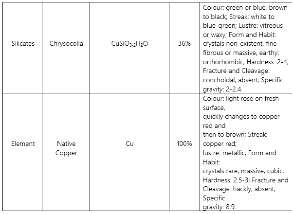
Q8) Discuss the physical properties of chief ores of copper.
Ans)


Q9) Discuss the minerals used in refractory industry.
Ans) A heat-resistant substance is refractory mineral. These minerals are resistant to decomposition by heat, pressure, or chemical attack and can sustain high temperatures. Refractory minerals can withstand temperatures of over 1500°C and can be used to make fire bricks. Aluminium oxides, silicon oxides, magnesium oxides, and calcium oxides are the most common materials utilised in the production of refractories. Minerals used in the refractory sector include:
Fireclay: Sedimentary clays are another name for fireclays. They are made up of variable quantities of the clay minerals kaolinite and illite, as well as fine-grained quartz/colloidal silica. Al2O3, SiO2 are the chemical components of fireclay. High-grade fireclays have 35–45 percent Al2O3, 2-2.5 percent alkalies, 2.1–2.5 percent Fe2O3, and 0.75 percent CaS and can resist temperatures of 1775°C. The two primary qualities required in fireclay for use in the construction of refractory bricks are refractoriness and plasticity. Refractory industries choose fireclay because it has a high alumina content and low iron oxide, lime, magnesia, and alkalies.
Graphite: Graphite is an allotropic form of pure carbon that resembles diamond and wood charcoal chemically. High lubricity, refractoriness (ability to sustain high temperatures), strong electrical and heat conductivity, and resistance to interaction with typical chemical reagents are all inherent properties of graphite. It's a dark grey-black colour with a greasy feel and a metallic sheen.
Dolomite: Dolomite, often known as dolostone, is an anhydrous carbonate mineral. Its colour is usually yellowish-white or brownish-white. It's a calcium (CaCO3) and magnesium (MgCO3) double carbonate (MgCO3). Dolomite is a type of rock that contains 40-45 percent magnesium carbonate. Dolomitic limestone is formed when the magnesium in dolomite is replaced by iron or manganese, with a lower amount of magnesium carbonate. Dolomitization involves the penetration of solutions through joints and fissures, and the conversion of thick layers of limestone to dolomite.
Magnesite: Magnesite (MgCO3) is a magnesium carbonate. The term ‘magnesite' is used in commerce to denote not just to the mineral, but also to a variety of goods made by calcining natural carbonate. By calcining crude magnesite at low temperatures (700°C to 1000°C), caustic magnesite is formed. Magnesite is calcined at high temperatures ranging from 1500°C to 1800°C to produce refractory magnesite. Pure magnesite is calcined at even higher temperatures, between 1600°C and 1800°C, to entirely eliminate carbon dioxide, resulting in 'periclase' (MgO).
Q10) a) Describe in detail the stages of mineral exploration.
b) Write about the geochemical exploration methods.
Ans) a) An exploration programme is defined as one that incorporates any or all of the four stages listed below:
Reconnaissance Stage
Reconnaissance is the first phase in any mineral exploration effort in an unexplored area. It's a regional-scale investigation of already-identified locations to look into enhanced mineral potential or prospects. Among the activities included in the reconnaissance survey are:
Regional geological mapping on 1:50,000 or 1:25000 scale;
Remote sensing and airborne geophysical survey;
Preliminary geochemical survey by chip/grab sampling of rocks: and
Weathered profile and pitting/trenching to expose mineralised zone/s an at ideal location.
Rock types and ore mineral assemblages are determined using petrographic and ore mineralogical research. Remote sensing and aircraft geophysical approaches can be used to identify advantageous features and magnetic anomalies/gravity anomalies on a regional scale.
The primary goal of this reconnaissance survey is to examine the entire wider region within the time frame allotted and to reduce that time by identifying the target area (perhaps mineralised area) for further investigation in the following stage. The targets are ranked based on the geological evidence that they are worth investigating further in order to find deposits. The reserve computation is usually not required at this point.
Prospecting Stage
The prospecting stage follows the reconnaissance survey and is usually done for smaller areas (up to few tens of sq. kms.). Prospecting is the process of narrowing down regions with promising improved mineral potential identified during the survey stage in order to find a mineral deposit. At this stage, you can participate in a variety of activities, such as:
outcrop identification;
detailed geological mapping on 1:25,000 or 1:12,500 scale;
ground geophysical; and
geochemical orientation survey/studies.
Rock/soil/stream sediments/debris sample is done at more frequent intervals. To expose the ore body, pitting and trenching, as well as restricted drilling, may be done at this stage. This stage may also include diamond drilling on wide-spaced section lines (100-1000 m depending on mineral types), petrographic and ore mineralogical analyses, and borehole geophysical logging.
The major goal is to conduct more definitive investigation in order to identify a deposit as a potential target for further exploration. Reserve calculations are done to appraise ore deposits based on the interpretation of geological, geophysical, and geochemical results.
Preliminary Exploration
The initial delineation of a discovered deposit over a relatively small area is known as preliminary exploration (less than a sq.km to a few sq.kms). Large-scale geological mapping on a scale of 1:5000 to 1:1000 is carried out at this stage. This is accomplished by combining prepared maps with a topo-grid and assessing lithology, structure, and mineralization. On all outcrop sections, a detailed litho-geochemical survey, pitting, trenching, and fresh bed rock and channel sampling are performed. Borehole geophysical survey and drilling on a systematic pattern up to 50 to 120 m depth and at an interval of 50 m – 500 m strike length (e.g., 50 m for gold, 200 m for base metals, and 400 m – 500 m for limestone) are also performed.
If necessary, a geophysical survey may be conducted. This stage includes extensive chemical analysis of samples for key trace elements with high precision, as well as bulk sampling for laboratory and bench size beneficiation experiments. The primary goal of this stage is to identify the mineral deposit's important geological features, such as commercially feasible zones, strike length, width, and depth. Surface studies and drilling data are used to identify them. These studies give a good indicator of an ore body's continuity. It also gives useful information about an ore body's shape, size, structure, and grade.
Detailed Exploration
Before mining or mine development, detailed exploration is carried out. For core samples and borehole logging, boreholes are drilled at tighter intervals along the strike and depth-wise. Exploratory openings, such as a trial pit for surface mining and a sub-surface entry with mine development on one or more levels for underground mining, are also carried out. This aids in the delineation of the ore-three-dimensional body's outline/contacts. They can also correctly evaluate the ore body's form, size, disposition, and grade. Beneficiation tests are performed, as well as database processing. With varying degrees of precision, mineral reserves are calculated and classified as Developed, Measured, Indicated, and Inferred.
The comprehensive exploration stage's major goal is to define a detailed three-dimensional ore body by sampling from outcrops, trenches, boreholes, shafts, and tunnels at close intervals. Reserves and average grades of ores up to the measured categories are also evaluated.
In the early stages of exploration, we learned that low-impact activities such as desktop research and field inspections are used to evaluate whether evidence of mineral/fuel resources are present. Following that, more intensive and expensive techniques such as geochemical sampling, drilling, and geophysical surveys are used. Every deposit has its own unique characteristics that influence the exploration methods used.
Depending on what qualities of the rocks/ore bodies are measured, many key exploration methods can be generically classified as Geological, Geophysical, and Geochemical approaches. The reconnaissance survey also requires remote sensing and picture interpretation; the investigation methods used for any given area are determined by natural conditions, unique needs, cost, time, and objectivity. Geophysical data combined with drilling provide accurate results in hidden areas, whereas geological methods do not. Geological prospecting methods, on the other hand, can be employed successfully in uncovered fold mountain locations. In folded, somewhat dissected landscapes covered with eluvium and colluvium, geochemical prospecting yields the most trustworthy data.
b) Conventional and non-conventional geochemical exploration methods are classified into two categories.
Conventional Methods
Under conventional technique, systematic measurement of one or more key or path finding elements in various sample media (such as soil, rock, stream sediments, glacier debris, water, plants, etc.) is carried out. Pedogeochemical, stream sediment, Lith geochemical glacial drift, and hydrogeochemical surveys are examples of traditional geochemical exploration techniques.
Non-Conventional Methods
Non-traditional geochemical exploration techniques are utilised in regions where traditional exploration techniques are ineffective, such as deep underground deposits covered by transported soil, desert sands, talus, or debris, among other things. The following are some examples of non-traditional geochemical exploration techniques:
Vapour or gas survey,
Electro geochemical,
Radiogenic isotope geochemistry,
Polymetallic poly nodule survey,
Hydrocarbon geochemical survey, etc.

100% Verified solved assignments from ₹ 40 written in our own words so that you get the best marks!
Don't have time to write your assignment neatly? Get it written by experts and get free home delivery
Get Guidebooks and Help books to pass your exams easily. Get home delivery or download instantly!
Download IGNOU's official study material combined into a single PDF file absolutely free!
Download latest Assignment Question Papers for free in PDF format at the click of a button!
Download Previous year Question Papers for reference and Exam Preparation for free!